

Montana Basin and Range
Montana Basin and Range
Extensional deformation in southwestern Montana caused by the movement of the Yellowstone hotspot bulge.

Welcome to Let’s Talk Outcrop, a weekly newsletter delivered every Tuesday where I explain Earth Science topics such as interesting geologic formations, Earth’s structure, physical Earth processes, or natural disasters (earthquakes or volcanoes). Other topics include famous geologic maps, minerals, or interplanetary science.
All Tuesday articles are free to all subscribers, though I also run a Friday series exclusively for paid subscribers. If you would like to upgrade to support my work and the sharing of science, gain access to my full writing archive, and gain access to my Friday series, use the button to upgrade your subscription.
Continuing this week on articles related to deformation following the movement of the Yellowstone hotspot track, the article of focus this week is by Robert Thomas and James Sears titled “Middle Miocene Through Pliocene Sedimentation and Tectonics in Montana: A Record of the Outbreak and Passage of the Yellowstone Hotspot".
The Yellowstone hotspot is responsible for many earthquake swarms, incredible geysers, and surface deformation and faulting where it is currently located. Still, as I've touched on in past articles the hotspot was not always at its current location.
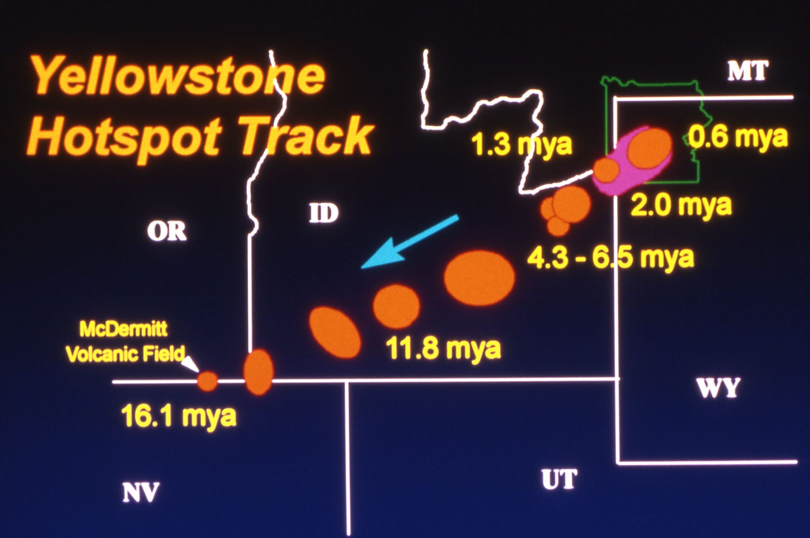
The track on Earth's crust behind the Yellowstone hotspot records deformation related to the crustal uplift and extension from upwelling magma.
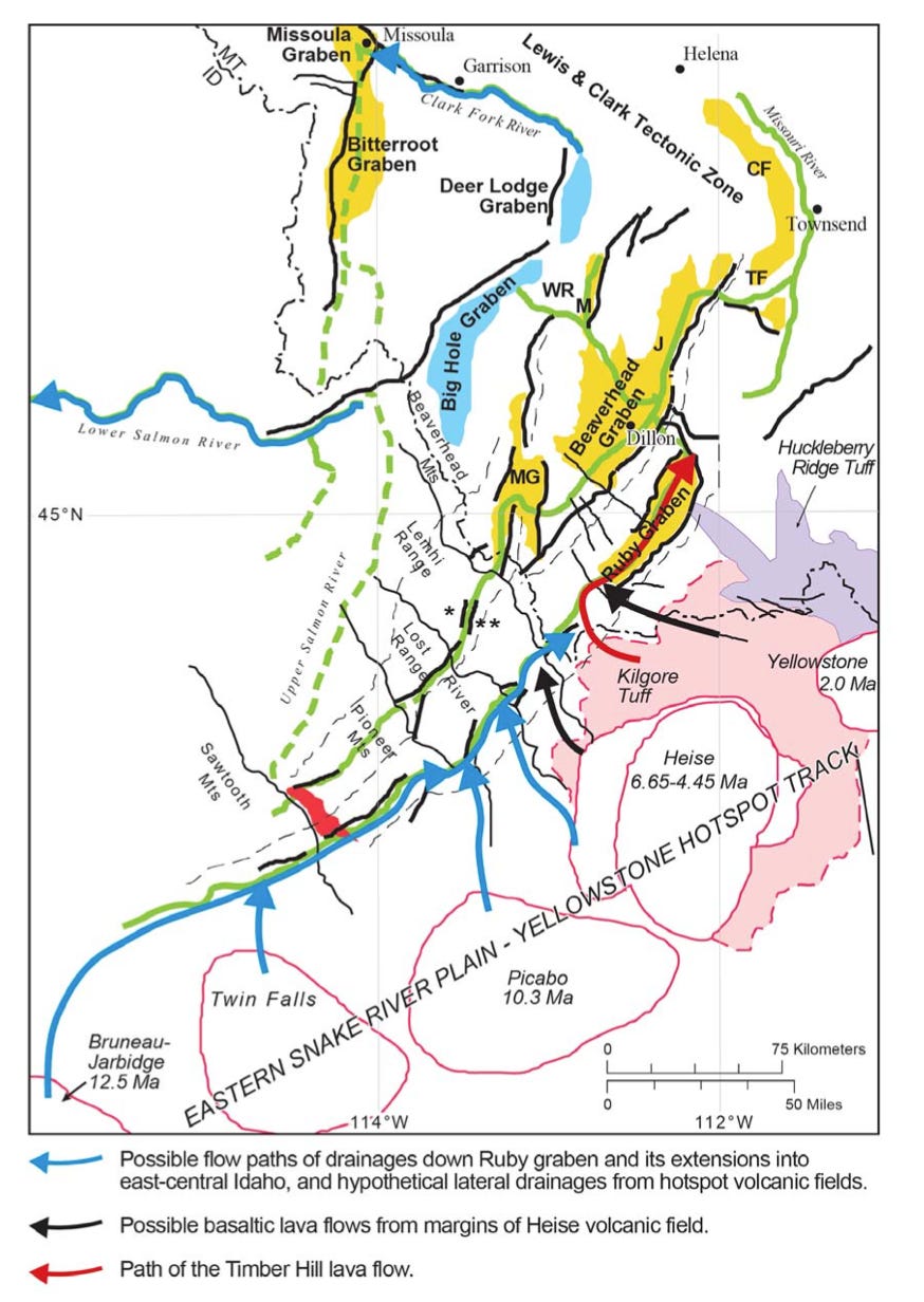
In western Montana, the Lewis and Clark Tectonic Zone records the movement of Yellowstone from ~17-2.5 million years ago.
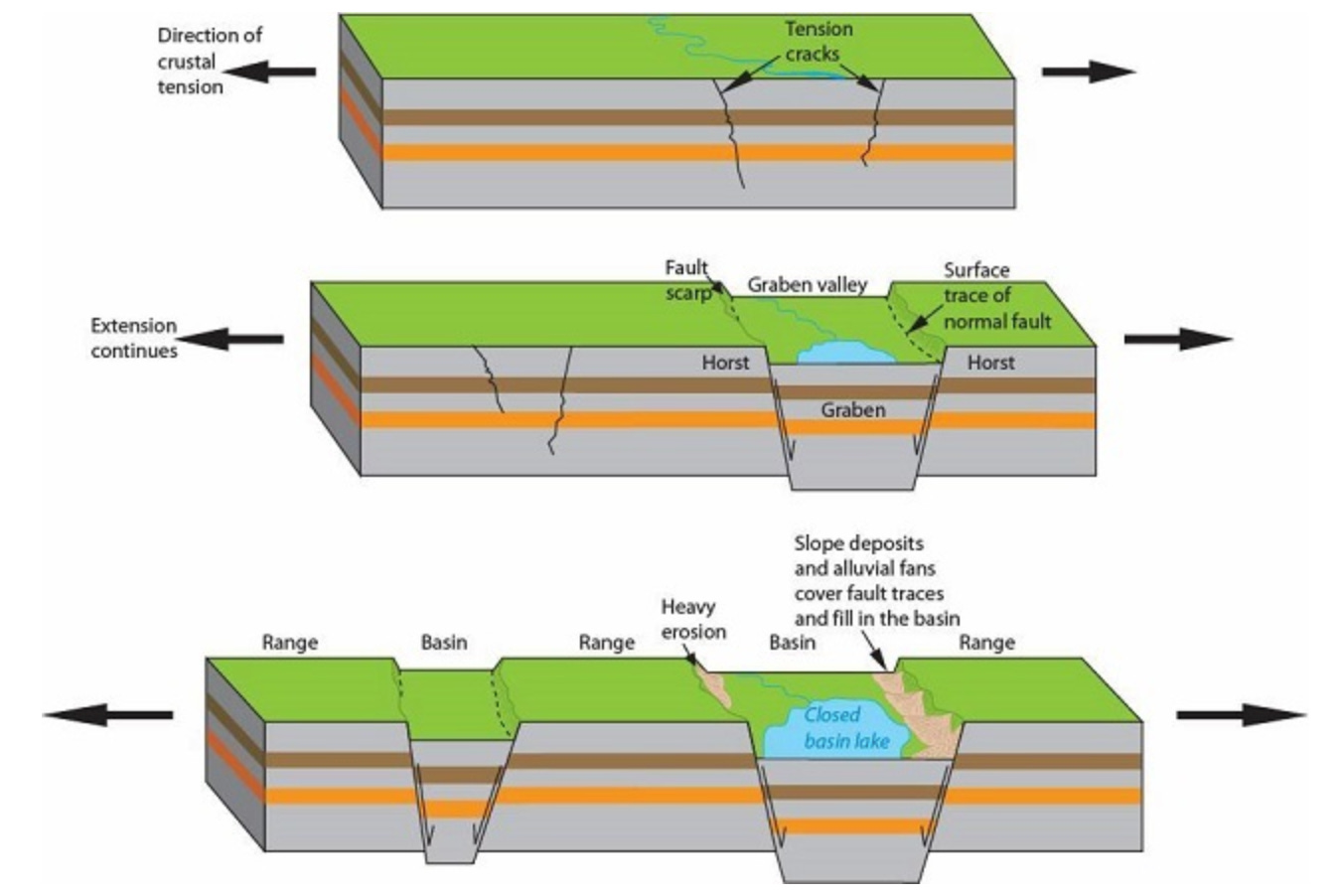
Large extensional blocks called "grabens" surround a large dome centered around the previous hotspot locations created from the bulge in the crust overlying the magma chamber.
Below, grabens are blocks in Earth’s crust that fall due to faulting and extension and are bounded by two normal faults. Half grabens form when a lowered block is bounded by only a single normal fault and only one side of the block drops.
Formations in Montana Recording Yellowstone's Movement
Southwestern Montana contains a Basin and Range Province with extensional horst and graben structures that began forming approximately 17 million years ago.
Northeast trending normal faults and basins act as sedimentary sinks collecting ash deposits and river-based sedimentary fans creating the Lewis and Clark Tectonic Zone.
The majority of these grabens radiate outward from the Yellowstone Hotspot track implying their creation is due to the movement of the Yellowstone bulge.
Grabens are spaced roughly 31-50 miles (50-80 kilometers) apart and are predominantly half grabens, bounded by only a single normal fault rather than one on each side.
In these half-graben basins, upwards of 10,000 feet (3,000 meters) of sediment has accumulated with deposits ranging from 820 to 10,000 feet (250-3,000 meters) thick.
Sediments deposited within these half-graben basins create a geologic unit named the "Sixmile Creek Formation".
The Sixmile Creek Formation unconformably overlies the older rocks in Montana, named the "Renova Formation" (meaning there is no smooth chronological deposition between the two layers, and there is missing time in the geologic record).
The Renova Formation has been tilted and is composed of significantly older rocks, whereas the Sixmile Creek Formation unit is predominantly horizontally bedded and comprises primarily of younger fine-grained sediments and many ash-rich layers. The Renova Formation is tilted and the Sixmile Creek Formation is horizontal, so the contact between this unit and the Renova Formation is specifically called an "angular unconformity" and termed the "Hemingfordian unconformity".
The Sixmile Creek Formation has been divided into three separate members: the Sweetwater Creek member at the base, the Anderson Ranch member in the middle, and the Big Hole River member at the top.
Sweetwater Creek Member
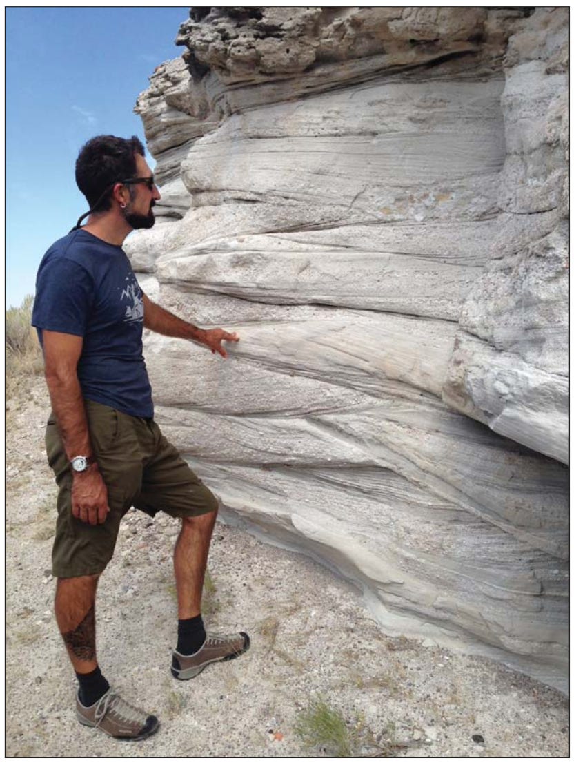
The Sweetwater Creek member of the Sixmile Creek Formation consists primarily of cross-bedded, sandy breccia.
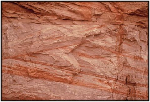
Breccia deposits are sedimentary rocks created by many different-sized clasts with sharp edges and corners that have been welded together. Conglomerate is similar to breccia, but clasts are significantly more rounded and don’t have sharp corners or edges. Smooth clasts are evidence of source environments far from depositional locations, so the rock fragments had more time to be weathered and rounded.

The cross-bedded breccia layers have been described as deposits from alluvial fans (triangle-shaped fans originating from water) and debris flows.
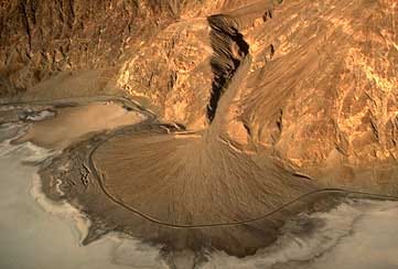
Rocks tested for source regions show that sediments in the Sweetwater Creek member were derived from local sources, most likely adjacent horsts.
Anderson Ranch Member
The middle member of the Sixmile Creek Formation is dominantly made of volcanic ash and tephra (fragments of rock ejected by an erupting volcano) deposits from Yellowstone eruptions. Tephra beds of the Anderson Ranch deposit are "silicic", meaning their chemical composition is rich in silica (an oxide of the element silicon).
Beds in the Anderson Ranch member are also cross-bedded, leading to the conclusion that the volcanic debris flow that deposited the material was very high energy. The geologic formation is a mixture of ash, pumice, sand, gravel, and other volcanic fragments.
Volcanic deposits from Yellowstone were formed as the hotspot migrated northeastward through Idaho to its present location.
Volcanic tephra deposits are important in geology for dating different layers using "geochronology". Geochronology is the science of dating geologic materials. Specifically for volcanic dating, ratios of 40Ar/39Ar. Argon (Ar) dating uses ratios of different isotopes (the same number of protons in a nucleus but a different number of neutrons) of an element - in this case, Argon - to determine a deposit's age. Potassium-40 (the parent isotope) in newly erupted volcanic material decays to Argon-40 (40Ar) over time. Argon-39 (39Ar) occurs naturally in rocks and the proportion of Argon-40 to Argon-39 gives a date of how old the volcanic deposit is.
Argon geochronology is accurate for dating volcanic deposits 5,000 to 6.25 billion years old and makes volcanic deposits terrific markers for geologists to date geologic features.
Tephra deposits in the Anderson Ranch member range up to 100 feet (30 meters) in thickness and give ages from 11.3 to 6 million years old, dating Yellowstone eruptions.
Big Hole River Member
The uppermost unit of the Sixmile Creek formation, the Big Hole River member, is composed of conglomerate rocks deposited by river and flood processes. Clasts within the conglomerate are well-rounded, indicating heavy weathering and long travel distances of rocks before deposition.
Clast sizes decrease to the northeast of the formation, indicating a northeastern flow direction, and slope increases to the southwest. Increased slope towards the southwest matches the direction of the Yellowstone hotspot, indicating a relation to the hotspot bulge as a factor in the flow direction of water-based deposits.
Lewis and Clark Tectonic Zone
The region in which the Sixmile Creek formation is deposited is termed the Lewis and Clark Tectonic Zone. As I previously mentioned, faults in this region are predominantly half-grabens, and trend radially outward from the Yellowstone hotspot.
Faulting coincides temporally with the upwelling of the Yellowstone hotspot, and the deposition of the Columbia River Flood Basalts in Washington and Oregon, which are hypothesized to be related to the head of the Yellowstone hotspot plume head.
The geologic formations captured within the half-graben basins in this tectonic region record old flow currents of rivers and volcanic flows over 10 million years ago. Basins are generally regions of low elevation where water flows. The basins here record historic flows of the Missouri, Salmon, and Yellowstone rivers.
Geology in this case provides not only the timing of Yellowstone eruptions and movement of the Yellowstone hotspot but also important information on how the landscape evolved and was shaped over time.
Thank you for reading! Share, comment, like, or consider a paid subscription to support my work and help get science out to others!
I’ve been fascinated with the geology of the region surrounding Yellowstone, and how the hotspot track has influenced the geology and tectonics of the region. I’ll probably swap back and forth between topics related to the hotspot and surrounding geology, and other random things for the next few weeks. If you have suggestions on anything specific you’re interested in, leave a comment and I’d love to research some things you are specifically interested in.
My 3 Favorite Posts from the Week


References
Thomas, Robert C., Sears, James W., (2020). Middle Miocene Through Pliocene Sedimentation and Tectonics in Montana: A Record of the Outbreak and Passage of the Yellowstone Hotspot. Montana Bureau of Mines and Geology Special Publication 122. 1. https://www.researchgate.net/publication/346646075.
Yellowstone Volcano Observatory, Stelten, M. E., (2024). A beginner's guide to dating (rocks). U.S. Geological Survey. https://www.usgs.gov/faqs/what-a-geoid-why-do-we-use-it-and-where-does-its-shape-come