

Seismicity Surrounding Yellowstone
Seismicity Surrounding Yellowstone
Review of the seismic hazard surrounding the Yellowstone and Grand Teton National Parks.

Welcome to Let’s Talk Outcrop, a weekly newsletter delivered every Tuesday where I explain Earth Science topics such as interesting geologic formations, Earth’s structure, physical Earth processes, or natural disasters (earthquakes or volcanoes). Other topics include famous geologic maps, minerals, or interplanetary science.
All Tuesday articles are free to all subscribers, though I also run a Friday series exclusively for paid subscribers. If you would like to upgrade to support my work and the sharing of science, gain access to my full writing archive, and gain access to my Friday series, use the button to upgrade your subscription.
I want to take one more week and focus on the geology and landscape surrounding Yellowstone and Grand Teton National Parks. I have been fascinated by this region lately and learned a lot that I enjoy sharing with you. I hope you’ve enjoyed this short series as much as I’ve enjoyed researching it! Before I get too carried away, I know I need to shift gears eventually, but I’d like to take one more look at the region. I study earthquakes and atmospheric wave propagation primarily, so this edition was a favorite of mine.
Earthquakes in the US are common in several regions; most obviously in California and Alaska where these states sit among major tectonic plate boundaries. The Pacific Northwest (Oregon and Washington) is also seismically active along a subduction zone but is much more quiet seismically than Alaska and California.
Hawaii and Yellowstone are the two other major seismically active regions in the United States and overlie active hotspots. (I wrote more about hotspots here, so check that out if you want to learn more about hotspot dynamics!)
Below is a color map I shared in Notes showing seismic hazards in the United States.
This week, I am focusing on the seismic hazard around Yellowstone and the Grand Teton, summarizing a 2009 paper in the Journal of Volcanology and Geothermal Research by Bonnie J. Pickering White and others.
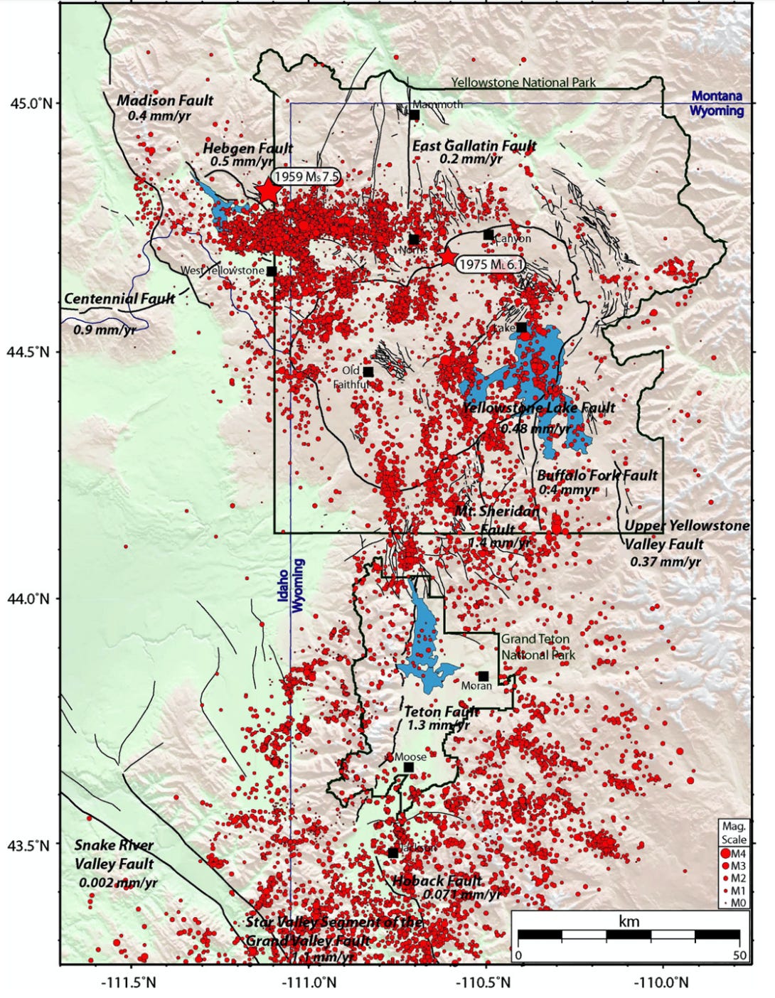
Seismicity around Yellowstone is focused within 31 miles (50 kilometers) of the hotspot and is primarily extensional due to the crustal bulge from the upwelling of magma.
Analyzing the seismic hazard (probability for an earthquake to occur) is important in the Yellowstone-Teton region due to the large numbers of visitors and residents in the area, primarily during summer months.
Previous Earthquakes
In 1959, a magnitude 7.5 earthquake struck Hebgen Lake in Montana - on the western edge of the Yellowstone National Park boundary - and caused the largest seismically triggered landslide in recorded history in North America. The quake collapsed the south wall standing 1,300 feet (400 meters) tall into the Madison River Canyon, creating a dam 220 feet (67 meters) high. The lake created behind the dam as the river filled the canyon is now also called “Quake Lake”.
In this tragedy, 26 people lost their lives in the surrounding campgrounds from a massive wave up to 100 feet (30 meters) tall that was triggered by the mountainside collapse into the river.
Also of note, is the 1975 Norris Geyser Basin earthquake of magnitude 6.1 that struck on the northern rim of the caldera.
The 1975 event was the largest recorded earthquake within the boundary of the Park, though luckily no injuries were reported. However, the interval between Old Faithful eruptions was increased by nearly three minutes.
Other events that catch the interest of media outlets, are repeated earthquake swarms that occur within the Yellowstone caldera region (notably the 1985 Yellowstone swarm where 3,000 earthquake occurred in two months, with over 200 events on two separate days). There is a complicated definition to (technically) be considered a swarm, but the gist is over 20 earthquakes occurring in the same vicinity in a short period of time. Many researchers attribute the occurrence of swarms to be caused by the movement of underground fluids that get expelled from solidifying magma in the beneath the caldera.
Tectonics and Major Faults
Faults surrounding the Yellowstone caldera have been active due to the movement of the hotspot over the last ~15 million years and in recent times due to hydrothermal fluid (ground water) circulation above the magma chamber, upwelling of magma, and flexural extension along the Yellowstone crustal bulge. Other possible attributions to crustal deformation is the addition and subsequent removal of glaciers during the last ice age.
Earthquakes in the Yellowstone-Teton region are (primarily) the result of crustal extension within a tectonic plate (called “intraplate” events). Most events within the caldera occur along North-South trending lines that lay sub-parallel to the major magmatic vent systems in the park. Near Hebgen Lake, associated seismicity following the 1959 earthquake and most seismicity in recent years follows East-West patterns, and is likely attributed to crustal flexure and extension from the Yellowstone hotspot bulge.
The major faults that contribute the most to the seismic hazard in the Yellowstone-Teton region are the Teton and Hebgen Lake faults. Other noteworthy faults with high slip rates also include the Mt. Sheridan, Madison, Gallatin, and Yellowstone Lake faults.
Read more about the Teton fault in one of my previous posts below.

To make a long story short, the Teton fault is a large North-South trending, east dipping normal (extensional) fault that is the culprit of many magnitude ~7 earthquakes throughout the last 2 million years. However, the Teton fault has remained seismically quite for earthquakes greater than magnitude 3 in recent times.
Earthquakes still occurring along the Teton Fault are primarily normal faulting events, indicating the crust is here is under East-West extensional stresses.
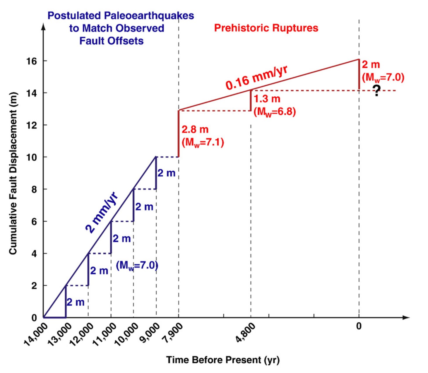
Most recently, the Teton Fault has generated two large (magnitude ~7) earthquakes: one 7,980 years ago and one ~4,800. The Teton Fault appeared to be most active between 14,000 and 8,000 years ago, potentially attributed to crustal rebound from the retreat of the 0.6 mile (1 kilometer) thick Yellowstone glacial mass.
The following image is a Figure from the highlighted paper (White et al., 2009), showing the fault displacement over time along the Teton Fault. Vertical steps show earthquake events estimated over time. Their analysis shows a significant decrease in slip rate occurring from ~7,900 years ago till now, and an accumulated 2 meters (6.5 feet) of slip deficit along the Teton Fault. The slip deficit indicates a large amount of stress built up along the fault which has not been dissipated through an earthquake, and can result in a possible rupture of magnitude 7.0.
Seismic Hazard
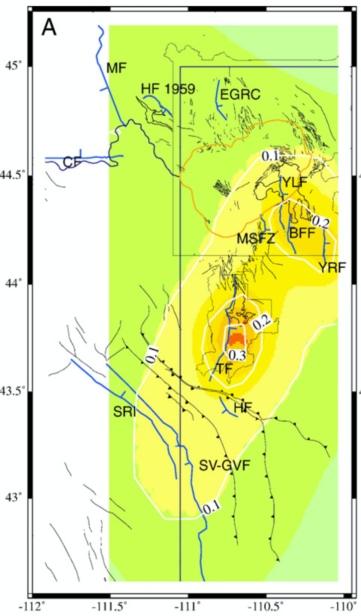
Including all 12 major faults in the Yellowstone-Teton region, the authors generate a seismic hazard assessment for the entire area. They find that earthquakes between magnitudes 6.5 and 7 are expected approximately every 200 years, and the Teton Fault poses the greatest hazard.
The slip rate and slip deficit along the Teton Fault is great enough that this fault is a candidate for the greatest seismic hazard in the entire United States.
Volcanic-related earthquakes are possible, but those associate with fluid migration and magmatic intrusions are generally lower than magnitude 6.5 and likely less than magnitude 5 for the Teton-Yellowstone region.
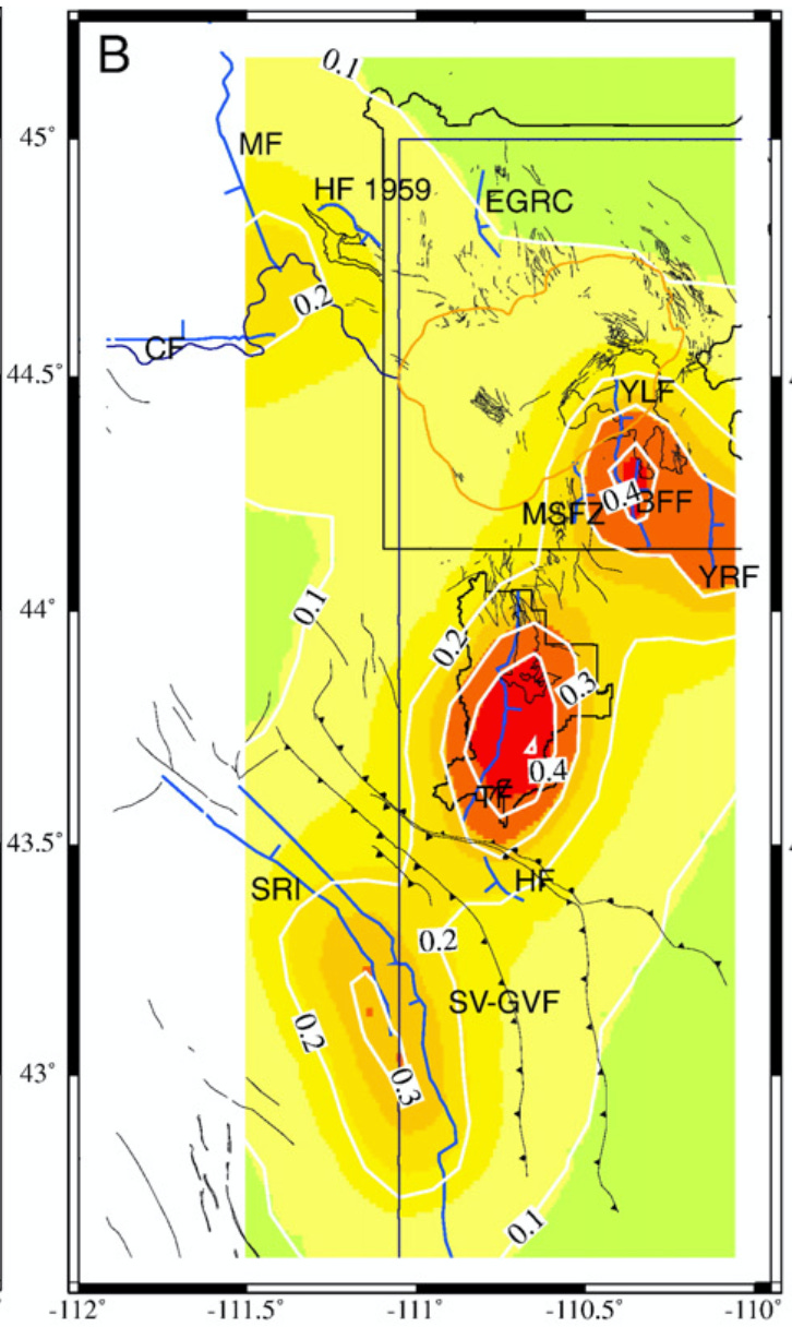
The authors present three probability-based seismic hazard maps for the Yellowstone-Teton region. (In the following images, colors indicate ground motion intensity felt during an earthquake as a comparison to the acceleration due to gravity. Actual values are difficult to understand but the important thing is red shows spots with a high probability of a large earthquake occurring. For those inclined, 1 g would represent an earthquake large enough to create a felt acceleration equal to the force of gravity, or 9.8 m/s2. A value of 0.3 would be 30% the force of gravity felt on the surface due to shaking, or 2.93 m/s2. All following hazard maps are figures from White et al., 2009)
In the next 500 years, a large magnitude event is likely to strike along the Teton Fault.
In the next 1,000 years, several earthquakes are likely to occur along the Teton, Buffalo Fork, Yellowstone Lake, and Yellowstone River Valley faults.

In the next 2,500 years, nearly all major faults in the Yellowstone-Teton region are expected to generate large earthquakes, and the Teton fault will likely rupture in an earthquake over magnitude 7, if not multiple earthquakes of that size.
Summary
Fortunately, the Yellowstone-Teton region does not house millions of people, like the deadly plate boundaries Seattle and Los Angeles reside. However, the seismic hazard is very high here, and the National Parks see millions of visitors a year. As evidence by the 1959 Hebgen Lake earthquake, people can be tragically impacted by earthquakes, especially those in regions where they seem unexpected.
To most, you may not consider Yellowstone to be a great seismic hazard, aside from periodic small-magnitude swarms; but these seem harmless.
However, the Teton Fault is certainly locked, and will inevitably rupture again in the future. The question is only, when?
Thank you for reading! Share, comment, like, or consider a paid subscription to support my work and help get science out to others!
My 3 Favorite Posts from the Week


References
White, B. J. P., Smith, R. B., Husen, S., Farrell, J. M., & Wong, I. (2009). Seismicity and earthquake hazard analysis of the Teton–Yellowstone region, Wyoming. Journal of Volcanology and Geothermal Research, 188(1-3), 277–296. doi:10.1016/j.jvolgeores.2009.08.015
Yellowstone Volcanic Observatory. (2024). The 1959 Madison Slide, Part 1: A deadly consequence of the Hebgen Lake Earthquake. Caldera Chronicles. USGS. https://www.usgs.gov/observatories/yvo/news/1959-madison-slide-part-1-a-deadly-consequence-hebgen-lake-earthquake
Yellowstone Volcanic Observatory. (2023). Phones out and a toppled chimney? There’s much more to the story of the 1975 Yellowstone National Park Earthquake! Caldera Chronicles. USGS. https://www.usgs.gov/observatories/yvo/news/phones-out-and-a-toppled-chimney-theres-much-more-story-1975-yellowstone
What’s the current thinking on a major volcanic eruption.
Very informative! Thanks, Jacob. In three weeks I and my wife will be spending a few weeks at YNP/GT and from decades of visits can attest we've always known about the thermal activity around Norris basin but NEVER about the threat posed by the Teton fault! Makes me look at that beautiful range in a whole new light!