

The Richat Structure
The Richat Structure
This enigmatic geologic feature also called “The Eye of the Sahara”, has several origin stories, with the location of Atlantis being amongst the most far-fetched.

Welcome to Let’s Talk Outcrop, a weekly newsletter delivered every Tuesday where I explain Earth Science topics such as interesting geologic formations, Earth’s structure, physical Earth processes, or natural disasters (earthquakes or volcanoes). Other topics include famous geologic maps, minerals, or interplanetary science.
All Tuesday articles are free to all subscribers, though I also run a Friday series exclusively for paid subscribers. If you would like to upgrade to support my work and the sharing of science, gain access to my full writing archive, and gain access to my Friday series, use the button to upgrade your subscription.

Humans have a natural propensity to see unnatural features within a natural environment.
Enigmatic clouds over a mountain that MUST be extraterrestrials.
Animals in the stars.
Faces in tree limbs.
Or perhaps my favorite, man-made structures within geologic formations.
One such cryptic feature whose origin has been debated is the Richat Structure in Mauritania, also called “The Eye of the Sahara”, or “The Eye of Africa". The concentric rings of exposed geologic formations creating the circular Richat Structure resemble a bullseye or onion-like shell and can let imagination run wild trying to figure out how this crazy feature formed.
The Eye of the Sahara lies in the African country of Mauritania within the Sahara Desert and is bounded by Archaean-aged (2.5-3.8 billion-year-old) basement rocks.
The Richat Structure is massive: ~28 miles (45 km) in diameter and visible from the International Space Station (ISS). Astronauts aboard the ISS were able to capture the following image with a common DSLR camera (Nikon D5) with a 50 mm focal length lens.

Geologic Structure
The Richat Structure contains rocks ranging from ~2.5 billion years old at the center, to ~460 million years old on the outer rings. Rings dip outward at 10-20 degrees, with several crosscutting faults within.
Concentric rings of sandstone, mudstone, chert, and limestone-dolomite sequences reveal a depositional environment under shallow marine waters full of organic material.
The center of the Richat Structure is composed of limestone-dolomite rocks that lie inside rings of silica-rich breccia deposits with multiple basaltic dikes, kimberlite intrustions, and other volcanic rocks.
Researchers have identified four different magmatic rocks intruding into the Richat structure, all of which lie within the dominant interior ring of the dome.
1) Basaltic dikes (vertical sheets of basalt) that have formed two rings within the circular geology.
2) Carbonatite dikes (vertical sheets of carbonate-rich volcanic rocks) that formed from the extension of the sedimentary layers.
3) Alkaline igneous rocks (magmas rich in alkaline minerals like potassium and sodium) crosscutting the inner basaltic dike.
4) Kimberlite pipes in the northern part of the structure. Kimberlites are vertical columns of igneous rocks that have risen from deep in the mantle. Commonly, kimberlites are important features for diamond mining, as these carry diamonds and other minerals that form deep in Earth’s mantle up to the surface. The kimberlite unit is not observable on the surface but has been identified through trenches and geophysical analysis of the Richat Structure. Many of the minerals in the kimberlite have hydrothermal alterations (e.g., chlorite and serpentine) suggesting interactions with water either during ascension through the mantle, or near-surface alteration with water near the underlying igneous pluton.
The breccia deposit at the center of the Richat Structure is ~2 miles across (3 kilometers) and 150 feet (40 meters) thick. Breccia is the name for a rock with many different-sized clasts that have sharp corners and edges (and thus lightly weathered) cemented together in a fine-grained matrix.
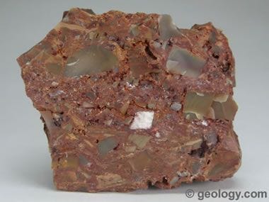
The breccia thins at the outermost regions of the circular formation to only a few feet (a few meters) thick, forming finger-like shapes at the outer boundary. Hydrothermal interactions with the breccia sediments deposited silica-rich minerals within the matrix and strongly enriched the cementing material with potassium, strontium, and barium.
Formation
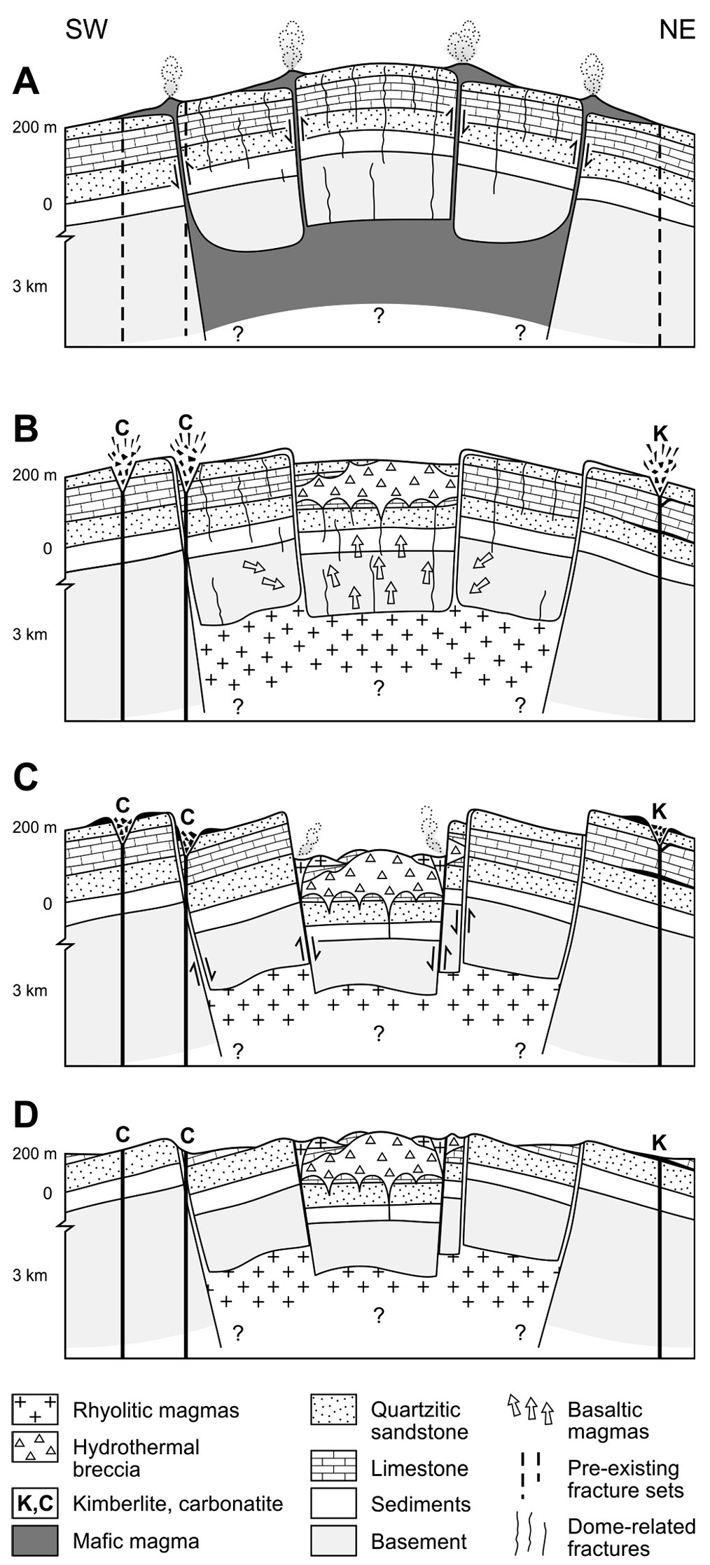
The most widely accepted theory for the structure of the Eye of the Sahara is a large dome formed from the upwelling of magmatic material and hydrothermal fluids which dissolved limestone and led to a central collapse that filled the cavities with sediments. Subsequent erosion of the domed structure scraped the top off the dome to expose the underlying concentric rings.
The dome appears to follow the form of an underlying magma chamber approximately one mile across (1.5-2 kilometers) and one mile (1.8 kilometers) deep which has since solidified to form an igneous pluton - whose intrusion into the crust uplifted the overburden rocks. Upwelling of magma likely began ~100 million years ago and formed a crustal dome above it.
Eruptions of magma from the magma chamber placed basaltic dikes through the much older rocks. Further eruptions from deep within the mantle created kimberlite pipes and carbonatite rings emplaced within the dome.
As the magma cooled, fluids expelled from the magma rose towards the surface carrying extensive dissolved minerals that interacted with sediments and the overburden to form hollow tunnels within dolomite and limestone which subsequently collapsed and formed the extensive central breccia.
Following the eruptions and after the magma chamber solidified, the dome was left exposed to the harsh winds and climate of the Earth’s surface. Millions of years of weathering and erosion cut the top off the dome to expose the magnificent underlying geology and central rings of the Richat structure.
The above discussion of the geology of the Richat Structure - primarily the center breccia - reveals large interactions of geology with fluids.
The breccia unit at the center of the Richat Structure shows evidence that it formed during karst dissolution (cavernous formation through limestone and dolomite via dissolving material with water) and collapse where surrounding sediments filled cavities measuring in diameters from a few inches to a few feet (centimeters to meters).
Isotopic analyses of the breccia reveal enrichment of rocks with alkaline-rich materials (namely sodium and potassium) and deformed feldspar crystals indicating a hydrothermal component to the formation of the Richat Structure.
Other Origin Theories
Though doming is common overlying magmatic intrusions, there are other ways for these domes to occur. One such explanation is from an asteroid impact.
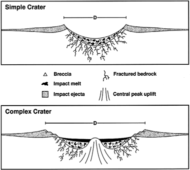
A similar dome exists in South Africa, called the Vredefort Impact Crater. Impacts can form dome-like structures with similar geologic compositions to the Richat Structure.
Asteroid impacts can uplift the surrounding geology and form a central depression, often with breccia deposits in their center. The impact obliterates the underlying geology, creating rock fragments, fine sediments, and fractures that can become cemented over time forming breccia deposits.
Surrounding the center of the impact, the underlying geology can be exposed in concentric rings, with layering dipping away from the center of the crater. These uplifts are generally unstable and normal extensional faults may surround the rings of the impact site.
Most of these features do exist at the Richat dome, though one important identifying feature is missing: evidence of shock metamorphism.
Shock metamorphism is the term used to describe extreme alterations of rocks. Rocks having undergone shock metamorphism from the effects of shock-wave-related deformation and extreme temperatures and pressures exhibit shatter-cones or parallel fractures within the crystalline structure. Common minerals formed from shock metamorphism are coesite and stishovite, both of which are absent at the Richat Structure. Coesite was believed to exist here but was falsely identified.
Perhaps the most unique interpretation of the Richat Structure is its attribution of the location of the city of Atlantis.
Several people have related Plato’s description of Atlantis - which was said to be a circular city with mountains to the north, interwoven with rings of water, and surrounded by an unfertile plain - to describe the Richat Structure.
Though the description does superficially match the VERY broad description of the Richat Structure - circular with mountains nearby and evidence of water - there is no real corroborating evidence to indicate the Eye of the Sahara is the location of the fictional city of Atlantis.
There are no remnants of a city, no archaeological sites showing an extensive history of civilization, or any other recounts of Atlantis (outside of Plato’s story) to suggest the city was located in Mauritania, or even real. There have been Neolithic spear points, stone tools, and other sparse artifacts found, but not near enough to suggest an extensive civilization lived here.
It it natural to let the mind wander to question how or why something formed and come up with unique solutions to complicated problems. However, we do need to remember to reign in the imagination at times before getting too carried away down rabbit holes. The Richat Structure certainly is one of the many amazing geologic formations where imaginations can get the best of us, and see something unnatural within the natural beauty of our planet.
Thank you for reading! Share, comment, like, or consider a paid subscription to support my work and help get science out to others!
References
Abdeina, E.H., Bazin, S., Chazot, G. et al. Geophysical modeling of the deep structure of the Richat magmatic intrusion (northern Mauritania): insights into its kinematics of emplacement. Arab J Geosci 14, 2315 (2021). https://doi.org/10.1007/s12517-021-08734-4
Matton, G., Jébrak, M., & Lee, J. K. (2005). Resolving the Richat enigma: Doming and hydrothermal karstification above an alkaline complex. Geology, 33(8), 665-668.
Matton G. & Jébrak, M. (2014). The “Eye of Africa” (Richat Dome, Mauritania): An isolated Cretaceous alkaline-hydrothermal complex. Journal of African Earth Sciences 97. 109-124. https://doi.org/10.1016/j.jafrearsci.2014.04.006.
Loved this, thank you!